The scenic Natchez Trace Parkway, a unit of the National Park Service since 1938, extends from the outskirts of Nashville, Tennessee, south to Natchez, Mississippi. The Parkway, according to promotional literature, “commemorates” or “memorializes” the historic Natchez Trace, a road that connected Natchez and Nashville during the early 19th century.
However, neither the purpose of the Parkway, commemorative or otherwise, or its relation to the old Natchez Trace are altogether clear. Much of the Parkway’s route is at a considerable distance from the historical road and frequently runs through bottomlands that would have been avoided by early travelers. Only occasionally does one encounter remnants of old Trace roadbeds. Additionally, interpretive signage along the Parkway indicates that actual sites are at a considerable distance, effectively inaccessible to the visitor.
Thus, the Parkway seems to violate the fundamental principle that historical parks have a close association with the site of a historic event. However, there was another purpose at work in the creation of the Parkway: the originators of the Natchez Trace idea had little interest in its form and shape. Rather, they wanted a federally funded road. For them, questions of history and heritage were not that important. The motivations behind the creation of the Parkway were contradictory and in part deceitful. The following account examines the process through which individuals and organizations developed and then manipulated the image of the Natchez Trace, all within the context of heritage organizations, road promotion schemes, and the pursuit of federal dollars.
Any consideration of the origin of the Natchez Trace Parkway must begin with the Natchez Trace. Originally a collection of animal paths, Native American hunting parties took advantage of the well-worn trail and followed the "traces" of the animal herds. In 1801, President Thomas Jefferson directed the army to improve the route. The term “Natchez Trace” refers to the road that during the early 19th century connected Natchez and Nashville, two frontier settlements separated by hundreds of miles of Native American Territory. The Natchez Trace, however, was never created as a single unit nor officially designated as such; it evolved from a network of roads and trails that lay between the two settlements. Furthermore, the name did not suddenly appear overnight; it gradually emerged during the early 1800s. For decades afterward, the Trace was mentioned only occasionally by historians.
The legacy of memory
During the 19th century, there was a proliferation of heritage organizations devoted to recovering, preserving, and commemorating history and historical places in order to promote national ideals and identity. The most successful was the Daughters of the American Revolution (DAR), founded in Washington, D.C., in 1890, to develop “an enlightened public opinion” and a “capacity for performing the duties of American Citizens” through “perpetuat[ing] the memory and spirit of the men and women who achieved American Independence; by the acquisition and protection of historical spots and the erection of monuments.” The society grew rapidly as local chapters were organized and each became involved in its own projects that included restorations, markings, and dedications.
Although the first commemorations were concerned primarily with sites associated with colonial and revolutionary war history, by the early 20th century the DAR began to mark historical roads, an idea that was probably influenced by the growing interest in improving roads. The first road commemorated was probably the Santa Fe Trail in 1907. Other trails included the Federal Road, the National Road, the Oregon Trail, the Camino Real, and the Natchez Trace.
Elizabeth Jones (1868-1949) of the Mississippi State Society DAR, first proposed marking the Natchez Trace. The wife of a planter in Holly Springs, Mississippi, she became Mississippi’s first DAR member in 1892. By 1906, she had been elected DAR regent for Mississippi, and the following year she proposed that the Mississippi, Alabama, and Tennessee DAR cooperate to mark the “great thoroughfare” known as the Natchez Trace. Her aim was to “trace with accuracy the very route” and “place monuments and markers” to inspire a sense of national pride and patriotism. In 1908, she urged each Mississippi chapter to purchase and erect a marker. The Corinth chapter responded first by erecting a monument in Tishomingo, and initiated a process that would gradually be completed by 1933.
History and hokum
The campaign for better roads that was sweeping America took full advantage of the increased interest in heritage and history. Road associations organized to coordinate road development beyond the local level and establish interstate highways linking major cities. Typically, each highway consisted of pre-existing roads maintained by a combination of local governments under the coordination of the association. Routes were determined by the level and location of local support, and the associations collected dues, marked the highways with identifying logos, and promoted them by publishing trail guides and newsletters. Road associations often promoted the highways under a heading based on historical and patriotic themes, thereby linking the project to the national mythos, such as the Lincoln Highway (New York-San Francisco), the Jefferson Highway (Winnipeg-New Orleans), and the Old Spanish Trail (St. Augustine-San Diego). The named trails set a precedent: historical images could be used as promotional gimmicks to play upon patriotic sympathies. As a result, history and heritage would be transformed into a veiled discourse intended to sell rather than educate.
The idea of developing a highway promoted on the basis of the Natchez Trace arose almost by happenstance. During discussions in the early 1910s over rival routes for a proposed “Jackson Highway” connecting Chicago and New Orleans, the Natchez Chamber of Commerce seized on the idea of routing the road through Jackson and Natchez, approximating the route of the Natchez Trace then being commemorated by the DAR. Convoluting history and semantics, supporters of the Natchez Trace gave this route the oxymoronic title, “the Natchez Trace route of the Jackson Highway.” The historical rationale was transparently self-serving, having little to do with determining the optimal route or following the actual Natchez Trace.
Although the Jackson Highway Association discarded its Trace route in 1915, the Natchez Chamber and the Natchez Federation of Women determined to form a new association to promote the Natchez Trace as a separate highway. The road in the new scheme would begin in Baton Rouge, Louisiana, at the Jefferson Highway and run north to Natchez and then northeastwards to its terminus on the Jackson Highway near Florence, Alabama – not exactly the historical Natchez Trace route. On January 19-20, 1916, about 300 people from twelve counties and parishes along the route of the proposed highway met in Kosciusko, Mississippi, under the auspices of the DAR and formed the Natchez Trace Highway Association.
Despite the initial fervor, the Natchez Trace Highway Association gradually faded away, as would the named trails movement. Passage of the Federal State Aid Road Act of 1916 provided federal dollars to the states for road construction and spawned state highway departments. Confronting the chaotic system of road names, the American Association of State Highway Officials in 1926 adopted a system for organizing and numbering roads throughout the country, which, when implemented, spelled the doom of the named trails. One critic complained that the new numbered system replaced “history” with “hokum.” He obviously did not recognize that the history was already substantially hokum.
The Prince of Humbug
In the early 1930s, the mercurial Colonel Jim Walton, whose flamboyant rhetoric and disregard for the truth would take the public in thrall, resurrected the Natchez Trace idea. Characterized by a restless wanderlust and a tendency to blur fact and fantasy, he claimed to have fled the United States during Reconstruction, been shipwrecked off the coast of Mozambique and entertained by the czar in St. Petersburg. After returning to the United States in 1886, he became a journalist, writing for newspapers in Charleston, Atlanta, and New York. By 1933, Walton, by now probably in his 80s, had settled in north Mississippi where he wrote for local newspapers and delved into local lore.
The March 10, 1933, dedication of the DAR’s Natchez Trace monument for Webster County at Mathiston, only eight miles from Colonel Walton’s Eupora home, set his imagination racing. In an unsigned news article he probably wrote, it was claimed that “the old Natchez Trace is probably the oldest highway in the world” and alleged that Mayans and Incas had traveled the Natchez Trace before Columbus discovered America. Such outlandish claims would play a prominent role in the rebirth of the “Pave the Trace” effort and in justifying its international aspirations.
At a meeting of the Good Roads Association in Beaumont, Texas, the following October, Walton issued a call for historical information on the Trace noting that there was “a movement [underway] to reopen the old Natchez Trace as a military highway from Nashville by way of Muscle Shoals, to Natchez.” (For Walton, “a movement” was often a euphemistic reference to himself.) Nevertheless, there was shrewdness to his plan. By the 1930s, highways were being constructed as joint federal-state projects using Federal Aid money matched by state funds. He reasoned that a federal military highway, however, would have to be financed and maintained exclusively by the federal government and that all traffic – military and civilian – could use the road, a compelling reason for local constituencies to support the project. He backed his claim that the Natchez Trace was “the oldest highway” in the world with the equally questionable claim that “Scientists from the Smithsonian Institute [sic] have found Indian picture writing records carved on stone that tend to reveal the history of the Trace as an intercontinental and intertribal highway in use 4,000 years ago.” His flamboyant assertions inspired numerous “progress-minded” newspaper editors to promote the project as a link in a vast pan-American highway connecting Canada and South America.
Walton next conferred with Congressman Jeff Busby in Houston, Mississippi, and U. S. Senator Hubert Stephens in New Albany. Busby immediately agreed to introduce legislation in Congress for the construction of a highway to run “from Nashville to the Louisiana-Mississippi line south of Natchez.” Busby also began an investigation of the history of the Trace. Significantly, he made decisions that had long-term consequences, changing the project into something that his constituents neither anticipated nor really wanted, namely a parkway. Like Walton, Busby wanted a project that would bring as many federal dollars into the state as possible, but he discovered that Colonel Walton’s basis for promoting the Trace as a military highway was bogus. Aware of other parkways under development by the National Park Service, such as the Blue Ridge Parkway, he determined to have the park service build the Trace road as a parkway.
The concept of parkways had been developed during the late 19th century in urban areas such as New York and Boston as a combination of park and highway to enhance the aesthetic experience and recreational pleasure of walking and driving. After the park service became involved in the creation of parkways in the late 1920s and early 1930s, it issued a document defining the key characteristics of parkways, such as including wide right-of-ways and scenic easements to provide a park-like ambience. To protect this ambience, commercial vehicles were prohibited.
By changing the Natchez Trace project from a highway to a parkway, Busby placed it on a course that would have two long-term consequences: it was not what the supporters wanted; and in reinforcing an emphasis on history, the parkway would be committed to an unattainable goal – reviving a road that it could not actually follow.
Meanwhile, Walton continued to crisscross Mississippi enlisting members from the ranks of politicians, government agencies, civic clubs, and patriotic organizations for his Natchez Trace Military Highway Association, extolling the Trace’s potential for becoming an international highway that would also “preserve our history and furnish work for some fifteen thousand unemployed.” Walton claimed to have growing political support, including Mississippi Governor Mike Connor, U.S. Senator Pat Harrison, Mississippi’s congressmen, representatives of the National Park Service, and the heads of the Alabama and Mississippi departments of archives and history. In fact, Dunbar Rowland, head of the Mississippi Department of Archives and History, had “very serious doubts … as to the feasibility or wisdom of attempting to induce the federal government to reopen and pave the old Trace ….” He pointed out that much of the road was still in use, while the commemorative aspect had been ably conducted by the DAR, leaving little reason for a new highway, commemorative or otherwise.
Regardless of the project’s merits, on January 10, 1934, over 150 delegates converged on the Edwards Hotel in Jackson, Mississippi, to organize the Natchez Trace Military Highway Association, later renamed the Natchez Trace Association. During the course of the convention, the Mississippi Legislature passed resolutions urging Congress to support the Natchez Trace legislation, in whatever form it might appear. Despite Dunbar Rowland’s lack of enthusiasm, the fervor for building roads trumped any qualms over history.
The price of everything, the value of nothing
In January 1934, Busby introduced an appropriation bill in Congress for $50,000 to survey a road “to be known as the Natchez Trace Parkway“ and a second bill appropriating $25 million for constructing the parkway. In hearings on March 5-6 before the House Committee on Roads, Busby couched his arguments for the project in terms of history and aesthetics, but his real objective was clear: the project would be of great economic benefit because “there is no system of roads that is adequate to this particular territory and there is not likely to be any for many years to come.” The hearings resulted in only a partial success. The survey bill passed, but the $25 million to construct the parkway was defeated.
Enactment of the survey bill established that the road would, indeed, be a parkway with all that it entailed rather than a highway formed from numerous county roads (including sections of the old Trace) spliced together and paved. Furthermore, the legislation stipulated that the forthcoming survey would locate the alignment of “the Natchez Trace [Parkway] as near as practicable to its original route.” This would effectively preclude attempts to move or extend it to towns far distant from the historical route. The consequences would play out over the following months as the National Park Service translated the legislation into a parkway plan, thereby bringing the fantasies and bluster that had come to dominate the Natchez Trace movement into conflict with the realities of legislation and the landscape.
National Park Service research on the history of the Natchez Trace had begun early, with three primary tasks in mind: to locate the Trace, identify historical sites on or near it, and write a narrative history. By early February 1935, the Bureau of Public Roads began locating the route of the Trace – and the route for the parkway. Working in consultation with the park service historians, the historical route was identified and mapped as carefully as possible. The survey determined that approximately 61 percent of the route was still in use as county roads, state highways, and city streets, prohibiting the use of those strips for the parkway. Furthermore, the survey revealed that the Natchez Trace was not simply one distinct route; it had, in fact, varied through time.
When faced with the dilemma of “rebuilding” the Trace without being able to follow it, the survey team finally brought into clarity that which had been ignored and obscured by years of fatuous rhetoric: the discrepancy between the fantasy image of the Trace and its physical reality. The wisest solution perhaps would have been to abandon the idea; after all, no legal commitments had been made, since the bill to fund the parkway had failed. However, the results of the 1935 survey were of little concern to the Natchez Trace movement, which, once in motion, had no intention of slowing down.
Because the plan to only approximate the route of the Natchez Trace violated the assumption that a historical park is actually on historical land, the discrepancy was justified by defining the Parkway as “memorializing” the Trace, which at first glance was little more than an acknowledgment of the DAR’s commemorative goals. In actuality, the term memorial was evidently used by the designers as a semantic ploy to gain the leeway to design something that was at least workable, given the inherent problems in the project. Bits of the original Trace, historical sites, and natural sites would be incorporated as roadside pull-offs, where feasible, to provide attractions for travelers.
Once the development plan was sketched out, the promoters faced a major hurdle: lack of construction funds. In late 1935, Congress allotted $1,286,686 in emergency funds for construction, and work began in September 1938. Unfortunately, the manner and time-frame of construction precluded the Parkway from becoming a major thoroughfare for passenger traffic in the 1930s. The Parkway was constructed in unconnected segments in a process that dragged out over decades. As a result, it was superseded by the divided-lane, limited-access roads initiated under the 1956 Federal Aid Highway Act. The Parkway was finally completed in 2005, at costs estimated between $400 million and $2 billion.
Today the aesthetically pleasing landscape of the Natchez Trace Parkway belies the confusion in motives that led to its creation.
Jack D. Elliott Jr. is a historical archaeologist for the Mississippi Department of Archives and History. This article is condensed from Elliott’s “Paving the Trace,” which originally ran in the Fall 2007 edition of The Journal of Mississippi History, Volume LXIX No. 3. Condensed by permission of the Journal.
Lesson Plan
-
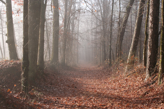
A preserved section of the old Trace along the Natchez Trace Parkway. Courtesy of the National Park Service. -
Emerald Mound is the largest Mississippian Period ceremonial mound along the Trace, and covers nearly eight acres. Courtesy of the National Park Service.
-

The Mississippi DAR placed markers "to trace with accuracy the very route" of the Natchez Trace in Mississippi. Courtesy of the National Park Service. -
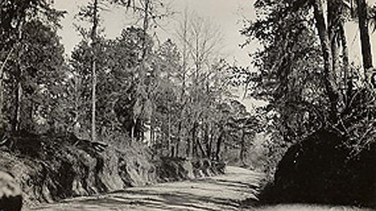
This 1935 photograph shows a portion of the old Trace that was modernized in Claiborne County, Mississippi. Courtesy of the National Park Service. -

Cypress Swamp along the Natchez Trace, about 25 miles northeast of Jackson, Mississippi. Courtesy of the National Park Service. -
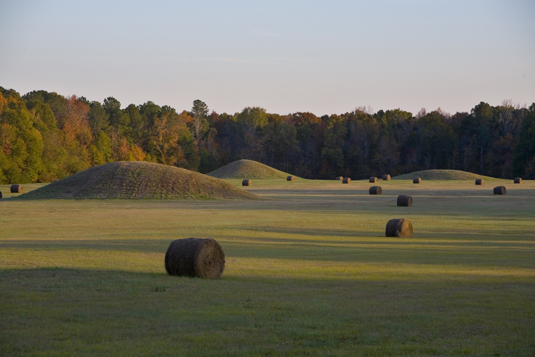
Pharr Mounds, a 90-acre complex of eight burial grounds, is located on the Trace 20 miles northeast of Tupelo, Mississippi. Courtesy of the National Park Service. -
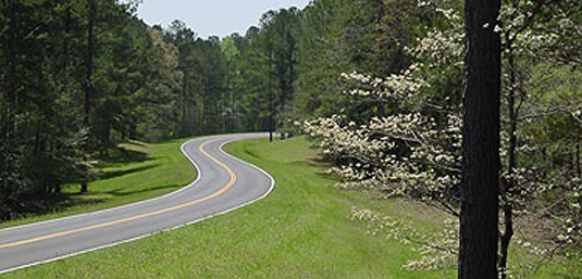
More than 100 species of trees, including the dogwood, grow along the Natchez Trace Parkway. Courtesy of the National Park Service.
Selected references:
Claiborne, J.F.H. Mississippi as a Province, Territory, and State. Spartanburg, S.C.: Reprint Company, 1978, reprint of the first edition, 1880.
Harper, Glenn A. “Preserving the National Road Landscape,” in Karl Raitz (ed.) The National Road. Baltimore, Md.: Johns Hopkins University Press, 1996.
Hunter, Ann Arnold. A Century of Service: The Story of the DAR. Washington, D.C.: National Society Daughters of the American Revolution, 1991.
Phelps, Dawson A. The Administrative History of the Natchez Trace Parkway
Ress, Thomas V. Encyclopedia of Alabama, "Natchez Trace."
Sullivan, Charles L. Building the “Old Spanish Trail”: The Story of a Modern American Highway. Jackson, Miss.: Mississippi Department of Transportation, 2003.
